Welcome to our blog ! Here you will find news and updates about sports, politics, artists, and everything that is trending right now. Enjoy the content and stay up to date with the latest trends! Stay Informed with BoomViral News.

Snow Totals Rise, Blizzard Alerts Expanded Across New York and Surrounding Region | Live Coverage
Suraay
2/22/20262 min read
NEW YORK (WABC) — A powerful and potentially historic winter storm is expected to hit the Tri-State area later today, bringing blizzard conditions, heavy snowfall, strong winds and the threat of coastal flooding.
The day began with scattered light snow and rain across parts of the region, but forecasters say the system will rapidly strengthen through the afternoon, with the most severe conditions arriving overnight.
Meteorologists warn this could be the most significant snowstorm to impact the area since January 2016 — the largest snowstorm ever recorded in New York City. Blizzard warnings, last issued in March 2017, are rare for the region. This storm is being fueled by energy moving in from the Ohio Valley combining with moisture from the Gulf and Atlantic, creating a powerful system reminiscent of a winter hurricane.
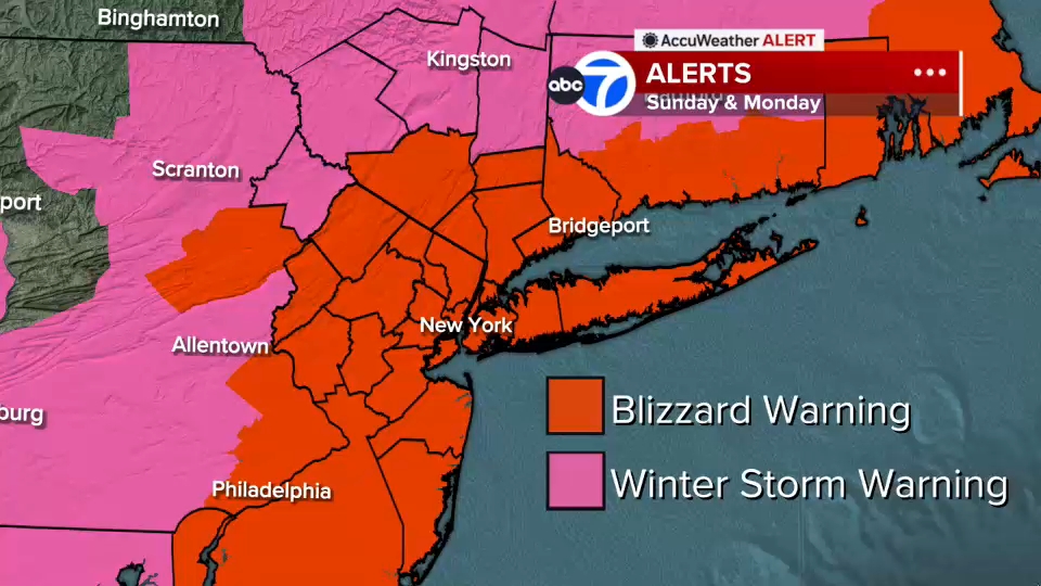
The National Weather Service has issued Blizzard and Winter Storm Warnings for New York City and surrounding counties from Sunday into Monday.
A Slow, Wet Start
Early this morning, light snow fell across Sullivan, Ulster, Dutchess and Orange counties, as well as parts of northwest New Jersey. Much of central and southern New Jersey saw rain, with brief sleet mixing in near Ocean County before changing over. Roads are mostly wet for now, which may slow early accumulation.
However, visibility is already reduced in some areas — dropping to just 0.2 miles in White Plains — and travel conditions are expected to worsen significantly as heavier snow develops.
Conditions Deteriorate This Afternoon and Evening
As the coastal storm strengthens and moves up the East Coast, colder air will push into the region, turning rain into snow across New York City and New Jersey by midday.
After lunchtime, snowfall is expected to become heavier and more widespread. By evening, intense snow bands are forecast to develop, bringing:
Snowfall rates of 1 to 2 inches per hour
Wind gusts between 50 and 60 mph near the coast
Whiteout conditions with near-zero visibility
Increased risk of power outages due to downed trees and power lines
All counties in the Tri-State area are under a Blizzard Warning.
Expected Snowfall Totals
With hours of heavy snow anticipated overnight, accumulation could be substantial:
12 to 18 inches across much of the region
18 to 24 inches possible in a corridor stretching from the Jersey Shore to Long Island
Highest totals — potentially over 24 inches — on the East End of Long Island and parts of the Jersey Shore
Up to 12 inches north and west, including Pike, Sullivan and Ulster counties
Coastal Flooding Concerns
Strong onshore winds may also cause coastal flooding, particularly during high-tide cycles tonight into early Monday. Forecasters say up to three feet of coastal inundation is possible along portions of Long Island and the Jersey Shore.
Storm Timeline
This Morning:
Light precipitation mix
Mainly wet roads
Localized visibility issues
This Afternoon:
Rain transitions to snow in NYC and New Jersey
Snow intensifies after midday
Tonight (Peak of the Storm):
Heavy, widespread snowfall
1–2 inches per hour rates
50–60 mph coastal wind gusts
Blizzard conditions and whiteouts
Elevated power outage risk
Monday Morning:
Snow continues early, then gradually tapers
Improving visibility by mid-morning
Strong winds persist, and travel disruptions remain likely
Residents are urged to complete preparations early and avoid unnecessary travel as conditions rapidly worsen.